About a week back I put up a post about "not feeling so bad" when running aground since a Navy submarine did so. That little bit of levity was written before I knew a sailor died in the "accident" and 60 sailors were serious injured. Turns out the sub ran smack into a mountain that wasn't on the chart. The sub was at 500 feet and travelling at "high speed". The mountain wasn't on the chart in spite of the fact that a previous gps satellite image showed the mountain. I find that more than a bit upsetting. I know Leo MacDonald served in subs for many years. I wonder if he, or any other submariner, has any comments on this.
I've included the entire article for those who wish to read it. You only have to read a few paragraphs to get the gist of it. After you read how slack they are in updating charts, perhaps any prudent captain ready to go to sea ought to visit West Marine and get his charts there!
--------------------------------------------------------------------------------
January 15, 2005
Submarine Crash Shows Navy Had Gaps in Mapping System
By CHRISTOPHER DREW
Sailors on the San Francisco, a nuclear-powered attack submarine, had just finished cleaning the vessel last Saturday as it sped along 500 feet beneath the surface of the South Pacific. Submarines run blind, just listening for sounds of danger. And to the captain and other officers relying on undersea navigation charts, everything seemed clear.
Suddenly, there was a horrible screeching. And according to an e-mail message written by a crew member, the inside of the submarine quickly resembled a scene from the movie "The Matrix." He wrote, "Everything slowed down and levitated and then went flying forward faster than the brain can process."
The submarine had crashed head-on into an undersea mountain that was not on the charts. One sailor was killed, and about 60 others were injured. Now, Defense Department officials say they have found a satellite image taken in 1999 that indicates an undersea mountain rising to perhaps within 100 feet below the surface there.
But the older navigation charts provided to the Navy were never updated to show the obstruction, they acknowledge, in part because the agency that creates them has never had the resources to use the satellite data systematically.
The officials said the main chart on the submarine, prepared in 1989 and never revised, did not show any potential obstacles within three miles of the crash. They said the incident happened in such a desolate area - 360 miles southeast of Guam - that updating their depiction of the undersea terrain was never considered a priority.
The new information about the charting flaws also illustrates what many experts say is a broader danger not only to submarines but also to many surface ships. At the same time, it provides a glimpse into the arcane task of plotting an undersea world that in some areas is still more mysterious than the surfaces of Mars or Venus.
A variety of satellite data is now showing that many sea charts, including some that still rely on notations from the days when sailors navigated by the stars, are inaccurate. And some scientists are calling for greater use of satellite data to fix more precisely the location of undersea ridges, islands and even continental boundaries and to chart large, less studied areas of the oceans.
The latest disclosures support the account by the commanding officer of the San Francisco that the charts showed that his track was clear. But former submarine captains said Navy investigators were likely to examine whether it had been prudent to travel at such a high speed, 30 knots, given the age and spottiness of the information.
Officials said the main chart on the submarine was prepared by the Defense Mapping Agency in August 1989. That office was later absorbed into the National Geospatial-Intelligence Agency, a part of the Defense Department that provides maps, sea charts and other geographic intelligence to the nation's combat forces.
Chris Andreasen, the chief hydrographer for the Office of Global Navigation at the intelligence agency, acknowledged in an interview that on the chart, "there's nothing shown that would be a hazard" at the crash site.
But since the accident, Mr. Andreasen said, his office has examined commercially available images taken by a Landsat satellite in 1999, and at least one image indicates that an undersea mountain could rise to within 100 feet of the surface there. Analysts say variations in water color can sometimes indicate a land mass below.
Mr. Andreasen said his agency had not normally used satellite imagery to update sea charts, though it recently began using the images to help pinpoint the boundaries of islands and other land masses. He and other officials said that the charting office's staff had shrunk in recent years, and that the Navy never asked it to focus on the area south of Guam, where it began basing submarines in 2002.
Current and former Navy officials say the main focus during the cold war was charting areas in the Northern Pacific and in Arctic seas where missile and surveillance submarines guarded against a Soviet attack. Since then, the Navy has been trying to improve charts of shallower coastal waters in the Middle East and other areas where it might have to help battle terrorists.
Mr. Andreasen said that since global positioning satellites came into wide use in the 1980's, Navy and commercial ships had had a much more accurate way to fix the coordinates of islands, undersea volcanoes and other parts of the giant mountain ranges that jut up from the ocean floor.
"G.P.S. is changing the world," he said.
As ships have reported these coordinates, sea-charting offices around the world have found that many islands were "maybe a mile or two out of position" on widely used charts, he said. So over the past year, his agency has been using the Landsat images and other data to update many nations' boundaries.
But Mr. Andreasen and other scientists said that while commercial shipping interests had helped chart the most common transit routes, large areas of the ocean depths remained little charted.
Dr. David T. Sandwell, a geophysics professor at the Scripps Institution of Oceanography in San Diego, said that about 40 percent of the oceans were "very, very poorly charted, and those areas are mostly in the Southern Hemisphere."
While many sea charts include obstacles and features spotted by commercial vessels, World War II warships and even 19th-century explorers, the best charts are made by survey ships that use sound beams to create detailed pictures of the undersea terrain. The Navy has only seven such ships, however, and scientists say it could take decades to chart the rest of the seas thoroughly.
As a result, Dr. Sandwell and others have suggested that the government make rough chartings of more areas with another type of satellite - one that uses radar to measure variations in the height of the ocean that can signal if mountains are below.
Dr. Sandwell said readings by one such satellite in the mid-1980's also indicated there could be an undersea mountain at the San Francisco's crash site. But he said the margin of error was too large for the studies to be conclusive. And Mr. Andreasen said much of the satellite data was too vague for precise charting.
Mr. Andreasen said the main chart used on the submarine showed that the only concerns were a small area of discolored water that had been noted three miles from the crash site and some coral reefs about 10 miles away.
Notes on the chart indicated that the discolored water was mentioned on a British sea chart in 1963, and Mr. Andreasen said the notation might even go back to World War II. He said the discoloration might have been just a temporary disturbance, or it could have been a sign of the undersea ridge.
Other notes suggest that some ships had reported depths of 5,000 to 6,000 feet nearby. But Mr. Andreasen said few commercial ships used the area, and "it has never been systematically surveyed."
Navy officials declined to comment, saying they are investigating the accident.
The submarine left Guam on Jan. 7 for Brisbane, Australia. The Navy said 23 of the sailors were seriously injured, and at least five had broken bones.
The e-mail message by the sailor was sent to several people involved with submarines, and as it circulated within the submarine community, one person provided a copy to The New York Times.
The sailor wrote that many crew members were eating lunch at the time of the crash, which severely damaged the vessel's bow. He said several sailors suffered "bad head wounds," and men in the engine room smashed against "lots of metal and sharp edges."
Still, he said that the vessel's damage control party "did everything exactly right even though they were hurt as well."
The message also said that the submarine was lucky to have an extra medic on board, and that its main medic, known as a corpsman, did not sleep during the two-day trip back to port.
The Navy has said a machinist's mate second class, Joseph A. Ashley of Akron, Ohio, was knocked unconscious by the crash and died the next day from severe head injuries. The e-mail message said other sailors were surprised that the corpsman "got him to hold on as long as he did."
Copyright 2005 The New York Times Company | Home | Privacy Policy | Search | Corrections | RSS | Help | Back to Top
Setsail728@aol.com
Inadequate Charts!! Submarines!
Moderator: Jim Walsh
-
Zeida Cecilia-Mendez
Re: Inadequate Charts!! Submarines!
Warren, this is so terribly sad and inexcusable! It goes to show how lax our armed forces (air,land, sea) have become in the last years. Either by faulty charts, inadequate use of the modern technology, carelessness, faulty intelligence, and who knows what else, more mistakes are being made by all that are costing the lives of the men and women who serve. I am a fan of submarine sailing and the men who sailed them, have many many books on their history, their service, etc. Every time something like this happens (remember the one who surfaced too fast near Japan and sunk a japanese fishing vessel?) it makes me wonder... But regarding the charts at West Marine...maybe they are just as incomplete, don't you think? I'm going to contact Maptech Offshore Navigator (that's what I use with my GPS) and make sure they are updating their software accordingly !!!
Zeida
CD-33 Bandolera II
Miami, FL. (land free of underwater mountains)
zcecil@attglobal.net
Zeida
CD-33 Bandolera II
Miami, FL. (land free of underwater mountains)
zcecil@attglobal.net
-
Dick Barthel
Re: Inadequate Charts!! Submarines!
I think there must be other contributing factors. When the sub hit the Japanese fishing vessel a few years back, I was surprized to learn how young the crew was to include the Captain. They are typically very young people that we ask to operate these powerful high technologies. It is amazing there arn't more accidents.
In addition, I'm reminded about the horrible crash on the carrier some years back. A large part of the blame was put on the amount of hours the crews were working. Given the current strain on our military, I'm sure the unfortuante crew on that sub were not working 9-5 shifts!
I personally don't think we will ever really know all of the contributing forces leading to the crash because of the classified nature of submarine operations. We will hear what the government permits us to hear. But just like on our sail boats, it is usually a series of happenings that precedes a disaster.
Unfortuately there are a few leaders on that ship whose careers are toast whether or not they are truly responsible. Thank God the entire crew wasn't lost.
Dick
PS. On a lighter note, I wondered what Leo talked about on the submarines before he knew so much about Cape Dorys?
rbartr6NOSPAM@cox.net
-
Warren Kaplan
Re: Inadequate Charts!! Submarines!
Dick,
What you say about never knowing the whole story is undoubtably true. But let me tell you what bothers me about this tragedy..a sailor killed. The chart this submarine was using is vintage 1989. 16 years old. The stock and trade of the US Navy is ships at sea. I know I, in my "recreational CD27", would not go sailing into waters I did not know without a current UPDATED, accurate chart. I'd wager nobody reading this would either. This is a PROFESSIONAL Navy. An accurate chart is as basic a tool of that business as a sharp scalpel or a stethoscope is to mine. To do business without the basics, in either business, is ludicrous and can easily lead to tragic results.
I don't "buy" the excuse that the manpower isn't there to map the ocean and that this is a little used route. We are building space stations, we are mapping Mars and sending rockets into space all the time. We certainly have the technology and capability to finish mapping the oceans and certainly update the charts we already have. The fact of the matter is back in 1999 a satellite reported the undersea mountain the sub ran in to. That's 6 years ago! Nope. It won't wash. Updated charts must be very low priority amongst the powers that be.
Setsail728@aol.com
-
Tom Keevil
Momentum and Running Aground
I had a sobering and instructive experience this past fall on the hazards of running aground. I was sailing with a friend on his Balboa 26 on poorly charted Klamath Lake, Oregon, late in the season with the lake level relatively low. At one point we had the centerboard raised and were motoring about 4 or 5 knots when we struck a rock with the leading edge of the raised steel centerboard. Neither the rock nor the centerboard had any flexibility, and we came to an instant stop. Not many of us have had that experience of deceleration, as we usually slow down over a certain distance before stopping in the mud, or if we are about to t-bone the dock, we have a moment to prepare ourselves for the impact.
I was standing in the cockpit, steering with the tiller between my knees, with the companionway wide open. My next conscious thought was "what am I doing lying on the table down below?" The entire incident took place so rapidly that I was unable to process any sensory information - I didn't see, hear or feel a thing - I was instantly transported to a different place.
Needless to say, I was extraordinarily lucky, as I received one minor bruise, and my impact was cushioned by the table collapsing under me. Also, needless to say, we were travelling far too fast for the conditions, which included a blue-green algae bloom that made the water completely opague. Although I have studied a fair amount of physics, and could probably calculate the momentum and the forces involved, I was astounded to actually experience this effect myself. Be careful out there!
Tom Keevil
CD33 Rover
Charleston, OR
jeanandtom@hatsharpening.com
-
Leo
Navigation
Hi All,
I discussed Navigation, Nuclear Pwr, and commies )
)
The 'Submarine Community' (active, retired and related) is still receiving and processing info concerning the USS San Francisco collision.
Some current thoughts;
1. Best laid plans and still stuff happens . . . (known as "S_ _ _ Happens"). The is the most significant 'collision' with an underwater obstruction of which I am aware. But this stuff has and will happen. As mentioned in the report, with the current research funding level, corrections/updated will take many years. The CinCPacFlt (Commander Pacific Fleet) has ordered two investigations. The first, on ‘fault level’, if any and the second on how to prevent this from happening again. We will see something out of both.
2. The Commanding Officer ('CO', Captain, Skipper) is always responsible. Your fault, my fault, his fault or no ones fault, he is responsible (part maritime law and part Naval law.) From the preliminary info, it looks like no one on board was derelict in his duties. But I think the Skipper has a tedious hold on his career. A few years back a submarine surface under neither a Japanese research vessel with resultant loss of life. The CO of that boat was a good Skipper and from the onset insisted “ . . . he is responsible.” And he lost his job. Following that incident, it appears to me, that the Board of Inquiry gave immunity to the sailor that was at fault.
Fair Winds,
Leo MacDonald
Evening Light’ CD33
Pine Isl. Bay, Groton, CT
PS: I’ll be available at the NE Fleet Winter Meeting Jan. 29th to discuss this further.
I discussed Navigation, Nuclear Pwr, and commies
The 'Submarine Community' (active, retired and related) is still receiving and processing info concerning the USS San Francisco collision.
Some current thoughts;
1. Best laid plans and still stuff happens . . . (known as "S_ _ _ Happens"). The is the most significant 'collision' with an underwater obstruction of which I am aware. But this stuff has and will happen. As mentioned in the report, with the current research funding level, corrections/updated will take many years. The CinCPacFlt (Commander Pacific Fleet) has ordered two investigations. The first, on ‘fault level’, if any and the second on how to prevent this from happening again. We will see something out of both.
2. The Commanding Officer ('CO', Captain, Skipper) is always responsible. Your fault, my fault, his fault or no ones fault, he is responsible (part maritime law and part Naval law.) From the preliminary info, it looks like no one on board was derelict in his duties. But I think the Skipper has a tedious hold on his career. A few years back a submarine surface under neither a Japanese research vessel with resultant loss of life. The CO of that boat was a good Skipper and from the onset insisted “ . . . he is responsible.” And he lost his job. Following that incident, it appears to me, that the Board of Inquiry gave immunity to the sailor that was at fault.
Fair Winds,
Leo MacDonald
Evening Light’ CD33
Pine Isl. Bay, Groton, CT
PS: I’ll be available at the NE Fleet Winter Meeting Jan. 29th to discuss this further.
-
Ken Coit
No Sizzle, No Budget
You would think that we would have very accurate charts of the ocean floor and I suspect the Capt. of that sub thought as much. It is sort of like the shoaling of the ICW; until someone points out the cost of doing nothing there will be no action. Now that we know how much it costs, I guess we will be looking at that old satellite data and trying to correlate charts and images to make sure we haven't missed another undersea mountain. I note that we are now ready to expend $35 million or so on an expanded tsunami warning system that will cost $24 million a year to operate. Again, closing the barn door after the horse, but maybe well have another horse sometime.
I would imagine that other sub Captains will be asking for better information or abosolution from chart errors. Maybe that will get our collective attention.
BTW, don't they have forward looking SONAR on those subs? I can't imagine they would use it in wartime, but for just cruising at 30 Kts. in the "open" ocean, it would seem prudent.
Keep on sailing,
Ken
CD/36 Parfait
Raleigh, NC
parfaitNOSPAM@nc.rr.com
I would imagine that other sub Captains will be asking for better information or abosolution from chart errors. Maybe that will get our collective attention.
BTW, don't they have forward looking SONAR on those subs? I can't imagine they would use it in wartime, but for just cruising at 30 Kts. in the "open" ocean, it would seem prudent.
Keep on sailing,
Ken
CD/36 Parfait
Raleigh, NC
Warren Kaplan wrote: Dick,
What you say about never knowing the whole story is undoubtably true. But let me tell you what bothers me about this tragedy..a sailor killed. The chart this submarine was using is vintage 1989. 16 years old. The stock and trade of the US Navy is ships at sea. I know I, in my "recreational CD27", would not go sailing into waters I did not know without a current UPDATED, accurate chart. I'd wager nobody reading this would either. This is a PROFESSIONAL Navy. An accurate chart is as basic a tool of that business as a sharp scalpel or a stethoscope is to mine. To do business without the basics, in either business, is ludicrous and can easily lead to tragic results.
I don't "buy" the excuse that the manpower isn't there to map the ocean and that this is a little used route. We are building space stations, we are mapping Mars and sending rockets into space all the time. We certainly have the technology and capability to finish mapping the oceans and certainly update the charts we already have. The fact of the matter is back in 1999 a satellite reported the undersea mountain the sub ran in to. That's 6 years ago! Nope. It won't wash. Updated charts must be very low priority amongst the powers that be.
parfaitNOSPAM@nc.rr.com
-
Jeff S
Ranting and raving...
Some of the posts got me worked up, so I apologize in advance for my ranting...
Some comments from my perspective (approaching 16-ys of Active Duty in the Navy). I'll try not get on a soapbox and ruffle too many feathers, but...
In a lot of ways, it comes down to money. Budgets stretched thin iot pay for current operations (Iraq) and polital agendas (tax breaks), and a military being asked to do more (operations, training cycles, relief efforts) with less (money, man-power, time). Keep this in mind before launching criticism (lax behavior) and demanding change. Where do you put your priorities--on the micro (shipboard) and macro (DOD) level? Obviously, spending millions to conduct thorough charting of the vast reaches to the Pacific Ocean that were charted before (during cold war) isn't a big priority. Which Senator or Representative has that on their list of pork? Is NOAA or some private charting agency a big Republican (or Democratic) Party donor? Probably not (to both questions).
Everyday on my ship I'm amazed at the job my sailors are doing with the resources I'm given. While true that the military can learn something from the business world and some aspects of SecDef's "Transformation" policy are valuable, I'm concerned that we are cutting off our noses to spite our face.
We are in a dangerous business--there is risk in everything we do. Those risks can't be eliminated; however, we strive to understand them and control them in order manage them. Being human though, mistakes happen. It will be a while before we know all the facts surrounding this event...
Again, sorry for the soapbox ranting. These are just my opinions and please take them as such...
Jeff
1976 Ty #1271
Norfolk, VA
-
Warren Kaplan
Re: Ranting and raving...
Jeff,Jeff S wrote: Again, sorry for the soapbox ranting. These are just my opinions and please take them as such...
Jeff
1976 Ty #1271
Norfolk, VA
No soapbox ranting at all. I don't think anyone's posts, including mine, is placing blame for this with the sailors on the San Francisco, or, in fact, any of the sailors in the Navy who go to sea on any ship. The fault for this may NOT reside within the Navy at any level. But somewhere within the federal beaurocracy decisions were made, political or otherwise, not to provide adequate funds to map the oceans and keep naval charts updated an accurate. NOTHING will convince me that the technology isn't available to do the job. Nothing will convince me that there hasn't been the time available to do the job. Hell, chartmaking goes back hundreds of years and modern chartmaking goes back decades. I also know that with all the money we spend (we just ponied up $350 million at the drop of a hat for tsunami aid) money could have been found to update charts and make them current and super accurate. There is no excuse at all for dispatching one of our submarines, filled with living and breathing sailors with loved ones back home, speeding along at 30 knots at a depth of 500 feet into an area where the on board charts are suspect. And, if I read the article correctly, this is not a fluke. The status of Navy charts, according to the article, leave much to be desired. Its not right. These sailors put plenty on the line with each voyage as it is. They shouldn't have to go to sea and wonder if they are going to run hard aground, through no fault of their own, because of outdated charts.
Warren Kaplan
Sine Qua Non
CD27
Oyster Bay Harbor, NY
Wa
Setsail728@aol.com
-
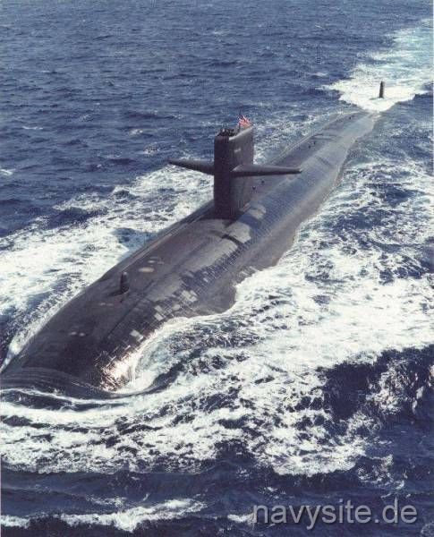
Ken Coit
Oh, ONE sub cost $900 Million circa 1980
There must be a contractor out there that can make the case for accurately and thoroughly charting the sea floor in order to save the costs of repair to a nuclear sub and the medical costs for injured crew. See the link for a description of the USS San Francisco.
Keep on sailing,
Ken
USS San Francisco stats
[img]http://navysite.de/ssn/ssn711_8.jpg[/img]
parfaitNOSPAM@nc.rr.com
Keep on sailing,
Ken
Warren Kaplan wrote: Dick,
What you say about never knowing the whole story is undoubtably true. But let me tell you what bothers me about this tragedy..a sailor killed. The chart this submarine was using is vintage 1989. 16 years old. The stock and trade of the US Navy is ships at sea. I know I, in my "recreational CD27", would not go sailing into waters I did not know without a current UPDATED, accurate chart. I'd wager nobody reading this would either. This is a PROFESSIONAL Navy. An accurate chart is as basic a tool of that business as a sharp scalpel or a stethoscope is to mine. To do business without the basics, in either business, is ludicrous and can easily lead to tragic results.
I don't "buy" the excuse that the manpower isn't there to map the ocean and that this is a little used route. We are building space stations, we are mapping Mars and sending rockets into space all the time. We certainly have the technology and capability to finish mapping the oceans and certainly update the charts we already have. The fact of the matter is back in 1999 a satellite reported the undersea mountain the sub ran in to. That's 6 years ago! Nope. It won't wash. Updated charts must be very low priority amongst the powers that be.
USS San Francisco stats
[img]http://navysite.de/ssn/ssn711_8.jpg[/img]
parfaitNOSPAM@nc.rr.com
-
JJ
What Are the Facts?
Cartography is not a perfect science; to believe that man has mapped out every canyon, mountain and underwater obstacle known is folly. With the recent tectonic plate shifts causing dynamic changes around the world (and under the surface) I would think there is enough work to keep a body of cartograhphers busy for years remapping both ocean surface and floors.
The charts we use in navigation are not completely accurate either. I would think few consistently correct their own surface charts using the latest Notice to Mariner and Local Notice to Mariner (on a weekly basis)? Your chart is only as current as your latest correction(s).
The Navy has an outstanding record of safety after millions of sea miles under her fleet's keels and Naval officers and enlisted receive some of the most advanced training in the world. We do not know all the facts of this particular incident. Going to sea is a dangerous job; going to sea underwater is an incredibly dangerous job.
As a retired Coast Guard Chief Quartermaster with years of buoy tender experience both as conning officer and navigator, I can say that positioning and repositioning aids to mark shoal water boundaries is a never ending process. Inlets shift, wave action moves shoals and severe weather can alter large areas of formerly navigable waterways. Positioning floating and fixed aids is a combination of technology, art and science.
I taught Inland/International Rules at the schools in Yorktown, Va. and used several studies of tragedies to enhance this vital yet potentially dry subject matter. These studies had been completed by boards of investigation and were extremely thorough in piecing together what had happened (i.e. the CGC Blackthorn tragedy in Tampa Bay)using ships logs, interviews with survivors and pieces of recovered hull and fittings. So, perhaps it's best to wait for the facts from the board of investigation before passing judgement.
And yes, the Captain is unconditionally responsible for what happens on his vessel, irrelevant if he is racked out or below on the messdeck getting a cup-o-joe while an inexperienced conning officer runs his ship aground or has a collision. The sea above or below is a hard taskmaster; suppose that keeps us humble - or it should...
-
Warren Kaplan
Re: What Are the Facts?
JJ,
I agree that cartography is not a perfect science. And I also agree that constant upgrades are necessary. Accidents surely will happen. With that as a given, let me tell you what disturbs me...at least from what I read in the article. This sub was travelling 500 feet below the surface and it hit a mountain that a satellite identified back in 1999 as rising to 100 feet below the water surface. That's no small object to ignore. The article also said that the chart was from 1989 and that a good portion of the charts throughout the navy are of "older vintage". I know notations are put on charts as they come in, but the article seems to imply that there really is not much priority and effort in updating the charts. I just feel that this country has the resources at hand to do a much better job in this area if the powers that be really wanted to do the job. Unfortunately it make take an incident like this to get it done, just like it often takes some little kid getting run over and killed at a dangerous traffic intersection to get the authorities to put in a traffic light.
One other observation and this is pure speculation on my part. It has been mentioned that we don't know all the facts. I agree. Often times information is held back. You also mentioned that the navy has an excellent safety record. I don't doubt that. But I'd be willing to wager that less serious incidents of navy ships running aground because of inaccurate charts happen much more often than ever gets reported to the public.
Please don't anyone think I have it in for the Navy. I don't. I have great respect for it. I just think it deserves better charts than its been getting. I'm quite sure the Navy wants them. I don't know who is is responsible for making it such a low priority.
Warren Kaplan
Sine Qua Non
CD27
Oyster Bay Harbor, NY
Setsail728@aol.com
-
Ken Coit
Re: What Are the Facts?
The press doesn't know everything and they don't always report accurately, but there is some evidence that the area had been known to have lighter colored water in 1963; "Notes on the chart indicated that the discolored water was mentioned on a British sea chart in 1963, and Mr. Andreasen said the notation might even go back to World War II. He said the discoloration might have been just a temporary disturbance, or it could have been a sign of the undersea ridge."
You'd think that you wouldn't run through the area at 30+ Kts. blind unless there was a notation on the chart that said to ignore the evidence. My current ICW charts show pilings just below the surface in the middle of the channel. How many times do you think they have been taken out by the barges and tugs?
The point is that the Navy deserves better charts when they are risking their lives below the surface, just as our soldiers deserve better armor.
Keep on sailing,
Ken
parfaitNOSPAM@nc.rr.com
You'd think that you wouldn't run through the area at 30+ Kts. blind unless there was a notation on the chart that said to ignore the evidence. My current ICW charts show pilings just below the surface in the middle of the channel. How many times do you think they have been taken out by the barges and tugs?
The point is that the Navy deserves better charts when they are risking their lives below the surface, just as our soldiers deserve better armor.
Keep on sailing,
Ken
Warren Kaplan wrote: JJ,
I agree that cartography is not a perfect science. And I also agree that constant upgrades are necessary. Accidents surely will happen. With that as a given, let me tell you what disturbs me...at least from what I read in the article. This sub was travelling 500 feet below the surface and it hit a mountain that a satellite identified back in 1999 as rising to 100 feet below the water surface. That's no small object to ignore. The article also said that the chart was from 1989 and that a good portion of the charts throughout the navy are of "older vintage". I know notations are put on charts as they come in, but the article seems to imply that there really is not much priority and effort in updating the charts. I just feel that this country has the resources at hand to do a much better job in this area if the powers that be really wanted to do the job. Unfortunately it make take an incident like this to get it done, just like it often takes some little kid getting run over and killed at a dangerous traffic intersection to get the authorities to put in a traffic light.
One other observation and this is pure speculation on my part. It has been mentioned that we don't know all the facts. I agree. Often times information is held back. You also mentioned that the navy has an excellent safety record. I don't doubt that. But I'd be willing to wager that less serious incidents of navy ships running aground because of inaccurate charts happen much more often than ever gets reported to the public.
Please don't anyone think I have it in for the Navy. I don't. I have great respect for it. I just think it deserves better charts than its been getting. I'm quite sure the Navy wants them. I don't know who is is responsible for making it such a low priority.
Warren Kaplan
Sine Qua Non
CD27
Oyster Bay Harbor, NY
parfaitNOSPAM@nc.rr.com
-
Neil Gordon
Re: Inadequate Charts!! Submarines!
>>The chart this submarine was using is vintage 1989.<<
As I recall, when I was on a heavy cruiser raiding the coast or North Vietnam, the best we could get were old French charts. Is not like you could buy charts of enemy controlled harbors at West Marine. We did the best we could.
By the way, I've looked and compared decades (and in one case a century or more) old charts of Boston harbor to the current chart. Except for dredging, the rocks and shoals are in the same place. Man made markers and other stuff has changed a lot.
As for risk of running aground in coastal waters due to an unknown hazard, it's always there. But coastal areas are much better charted than is the open ocean.
Fair winds, Neil
s/v LIQUIDITY
Cape Dory 28 #167
liquidity@NOSPAMnrordon.com
-
Max
Re: Inadequate Charts!! Submarines!
I'm curious about how subs work. Do they have sonar that will tell them about objects ahead of them or to the sides? If so, was this one not using it for some security reason? I wonder if there is something akin to passive sonar that would sense large objects (mountains) that wouldn't give away the position of the sub due to sending out signals to be bounced back.
max@inka.mssm.edu
max@inka.mssm.edu