I have a question for all the marine electronic techno experts....which I am not one.
I currently have a Raymarine SL70 stand alone radar with a 24NM radome that mounts at my nav station and also on my binnacle. I have it linked it to my Garmin GP51 GPS via nmea data feed so it can display my location data, waypoint, tracking, and route details on the radar screen. I understand the SL70 is not SeaTalk compatible so it can not be fully integrated with the newer chartplotters on the market, so I want to look at my options for installing a new stand alone chartplotter.
Any recommendations on a chartplotter? I will be mounting in along side my radar screen at the helm so I want weatherproof, and a bright enough screen to vis in direct sunlight. I am considering the Raymarine A70, although I am still looking for feedback. I am also wondering if I can use my existing Garmin GPS antenna with a replacement chartplotter (it is currently mounted on an aft radar pole and replacement would be tricky).
Any recommendations?
Thanks,
Chris
Chartplotter Recommendations......Integrations Advice
Moderator: bobdugan
-
Chris Reinke

- Posts: 179
- Joined: Apr 14th, '05, 14:59
- Location: CD330 - Innisfail (Gaelic for "A Little Bit Of Heaven on Earth"), Onset, MA
-
Jeff and Sarah
- Posts: 437
- Joined: Aug 25th, '09, 17:03
- Location: CD33 "Prerequisite" / CD28 Flybridge Trawler "Toboggan"; Annapolis, MD
I'm no expert, but I'm leaning towards the Garmin 740s. Networkable chartplotters are too expensive since they cost a couple thousand each and you need at least 2 of them to even realize their capability. The new 7 series seems to walk that fine line of high capability while only losing networking with another GPS. It works with NMEA 2000 components, and people seem to like the touchscreen system.
I think I'm going to go with the Radar bundle package that is available with the 740s. I haven't ordered it yet, but it's just a matter of time.
I think I'm going to go with the Radar bundle package that is available with the 740s. I haven't ordered it yet, but it's just a matter of time.
-
Joe CD MS 300

- Posts: 995
- Joined: Jul 5th, '05, 16:18
- Location: Cape Dory Motor Sailor 300 / "Quest" / Linekin Bay - Boothbay Harbor
I don't know how old your radar is but I'm a big fan of the radar overlay on charts. It provides a great confirmation of the location the GPS is giving you. If I was starting from scratch I world definitely go with Garmin. A lot of flexibility and not in the financial trouble that Raymarine is.
Better to find humility before humility finds you.
-
mahalocd36

- Posts: 591
- Joined: Feb 5th, '05, 10:51
- Location: 1990 CD36 Mahalo #163
- Contact:
Before you buy a Raymarine chartplotter, hop to your local marine store and try to actually use one. Try to pick a point on the chart and "goto" it. Scroll around, etc. Then try to use a Garmin or Standard Horizon. Actually looking at a manual is cheating. That might make your decision for you. 
Melissa Abato
www.sailmahalo.com
www.sailmahalo.com
-
Zeida

- Posts: 600
- Joined: May 27th, '05, 07:10
- Location: 1982 CD33 "Bandolera II" Hull #73Key Biscayne-Miami, Florida
- Contact:
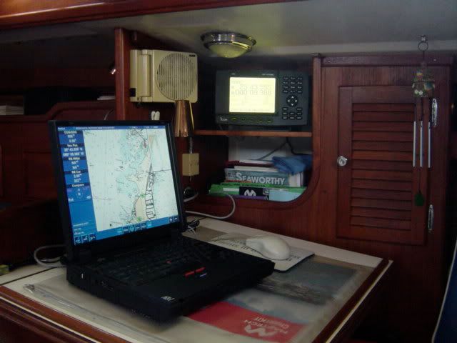
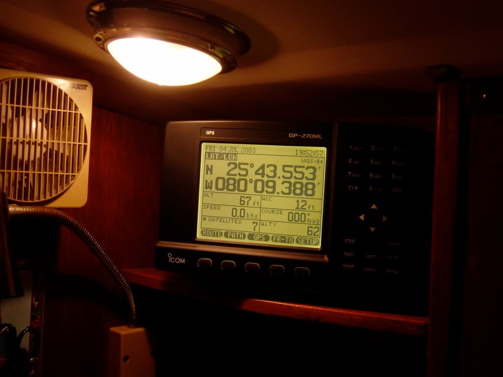
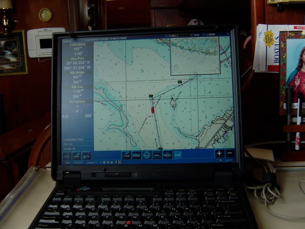
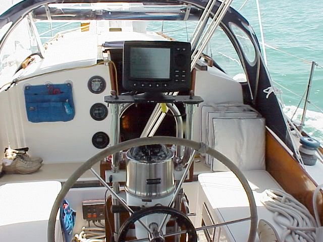
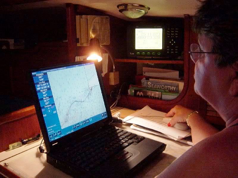
Melissa, what is your current setup on Mahalo? Are you 100% happy with it? Since the good color chartplotters are awfully expensive, this is one area where I have needed to improvise. I ended up buying a $220.00 Icom GPS, which is very easy to use, nice large numbers and info and connected it to the laptop which has the Maptech Offshore Navigator software which I think was around $450. to buy. I need to keep these two inside my nav station, and I have to peek from the steering ped. to look at the screen, but this is doable. I also keep a small, old Magellan black and white smaller GPS at the pedestal by the wheel, and when under way, I am constantly comparing notes between the two. I normally work out the routes and plan out trips in the inside unit, since the maptech offshore program is very good. Of course, I wish I had the $$ to buy the bigger color units that you can have in the cockpit, but I guess there are other priorities. in any case, here is my navigation version.
<a href="http://i214.photobucket.com/albums/cc26 ... top010.jpg" target="_blank"><img width="600" src="http://i214.photobucket.com/albums/cc26 ... 0.jpg"></a>
<a href="http://i214.photobucket.com/albums/cc26 ... top005.jpg" target="_blank"><img width="600" src="http://i214.photobucket.com/albums/cc26 ... 5.jpg"></a>
<a href="http://i214.photobucket.com/albums/cc26 ... _00367.jpg" target="_blank"><img width="600" src="http://i214.photobucket.com/albums/cc26 ... 7.jpg"></a>
<a href="http://i214.photobucket.com/albums/cc26 ... _00347.jpg" target="_blank"><img width="600" src="http://i214.photobucket.com/albums/cc26 ... 7.jpg"></a>
<a href="http://i214.photobucket.com/albums/cc26 ... _00364.jpg" target="_blank"><img width="600" src="http://i214.photobucket.com/albums/cc26 ... 4.jpg"></a>
Zeida
CDSOA Member
CDSOA Member
-
Jeff and Sarah
- Posts: 437
- Joined: Aug 25th, '09, 17:03
- Location: CD33 "Prerequisite" / CD28 Flybridge Trawler "Toboggan"; Annapolis, MD

Definately would go with garmin here. I had an SL70 Raymarine on my boat when I bought it, I opted to do a total electronics refit (insturments, radar, everything). So I decided on Raymarine since they offered everything with simple linking, which I have been entirely happy with (except the autopilot I added a year ago to replace the old cetrek that finally died, nothing but trouble with the Raymarine ST70/X10 autopilot, over 2000 miles on it and it has not worked yet for more then 200 and has had to go back to Raymarine for software updates 2 times and mechanical repairs 2 times due to being destroyed by bad software! but I digress). But working with the system you have and integrating to it, you are better off with Garmin, better UI and generally friendly integration with non Garmin componants (Raymarine supports NEMA, but some features you expect might not exist unless you use one of the many variations of SeaTalk which mostly will not work anyway with your SL70, Raymarine is not big on backward compatability).
Russell
s/v (yet to be named) Tayana 42CC
s/v Lady Pauline Cape Dory 36 #117 (for sale)
s/v (yet to be named) Tayana 42CC
s/v Lady Pauline Cape Dory 36 #117 (for sale)
-
Maine Sail
- Posts: 839
- Joined: Feb 8th, '06, 18:30
- Location: Canadian Sailcraft 36T
My pick..
My pick would be to ditch the old stuff, it's getting long in the tooth to be considered dependable for marine electronics, and go Garmin 740 series with a GMR 18HD radar dome.
The 740 series has a built in antenna and is very, very easy to wire and hook up.
Another option that can save lots of money is to find a dealer who still has an older 3206 plotter but for the feature/benefit of the new 740 series it really wins out..
The 740 series has a built in antenna and is very, very easy to wire and hook up.
Another option that can save lots of money is to find a dealer who still has an older 3206 plotter but for the feature/benefit of the new 740 series it really wins out..
Garmin 3206
I like Maine Sail's 3206 idea.
I found one for $750 (google "shop"). Best part might be that you can network it with the new 4200 line if you later want to put the 4200 at the nav station. The way the garmin tech explained it to me, the 3206 will have complete N2000 functionality if it is connected to the 4208.
I bought a Garmin 441 to sail back from Florida with and I really like the interface and the loaded info such as "local services" and "tides" is great. The 441 is trully standalone and a bit too small . . . for not much more $$$, the 3206 will provide the bigger screen, radar overlay and the ability to run the autopilot.
Matt
-
mahalocd36
- Posts: 591
- Joined: Feb 5th, '05, 10:51
- Location: 1990 CD36 Mahalo #163
- Contact:
We are very happy with our setup, but it's not ideal, because I think ideally we'd have radar overlay with charts.Zeida wrote:Melissa, what is your current setup on Mahalo? Are you 100% happy with it?
Here's what we have:
Mahalo came with a Raymarine radar system on a swing out arm from the companionway. This setup works well, can see it from helm or under the dodger, or in the cabin. However it doesn't have chartplotting capabilities, though are GPS interfaces with it to give it speed and direction.
Under the dodger we have a Garmin charplotter (492C I think) that we like. Very easy to use.
At the helm last year we added a Standard horizon CP3000 7" chartplotter. I wanted a larger chartplotter than the garmin but we didn't feel like spending *too* much $$ and this was a nice compromise. I love it. It has the feature of being able to split the screen into 2 views - like one distant and one zoomed in.
On our laptops we have navigation software that frankly we don't really use anymore. It did get use when we just had GPSs without chartplotting. However we don't do a lot of route planning like some people do. The 2 chartplotters we have are so easy to use - just point and 'goto' that we don't usually plan out a route in advance on the chartplotter (we do looking at a paper chart and discussing where we are going to go and how we are going to get there, but we don't worry about having a GPS route all planned out) . Besides Winds, plans and moods change
When the radar hits the end-of-life, which hopefully won't be for a while, we'll change out of Raymarine to something easier to use, integrated with a chartplotter.
Melissa Abato
www.sailmahalo.com
www.sailmahalo.com
-
Zeida
- Posts: 600
- Joined: May 27th, '05, 07:10
- Location: 1982 CD33 "Bandolera II" Hull #73Key Biscayne-Miami, Florida
- Contact:
Jeff... I think the "altitude" reading in my ICOM GPS refers to the approx height of where the satellites are "seeing" my boat.
When I was filling in the info on the unit itself, it asks the location and highest point of the boat, which was my mast (54 ft.) and that is what I put in there... so I assume that altitude reading has something to do with that. For sure, I am not flying...
When I was filling in the info on the unit itself, it asks the location and highest point of the boat, which was my mast (54 ft.) and that is what I put in there... so I assume that altitude reading has something to do with that. For sure, I am not flying...
Zeida
CDSOA Member
CDSOA Member
Integration
Integrating your electronics is nice, but we all know that electronics fail, If you are going to have radar/chartplotter combinations . I like the following setup; radar /chartplotter in nav station, and chartplotter at helm. I prefer them not nema interconnected. That way I have two independent gps' working for safety and comparison.
I use Standard Horizon chatplotter and raymarine radar/chart. The reason is that the same c map charts fit in both units, and I don't have to buy duplicate charts. The down side is that the charting function can only be used one at a time. The upside is that routes, marks, etc. can be moved from the helm to the nav station to a computer ( with map tech charts) with relative ease. No data is lost if one of them goes down.
I use Standard Horizon chatplotter and raymarine radar/chart. The reason is that the same c map charts fit in both units, and I don't have to buy duplicate charts. The down side is that the charting function can only be used one at a time. The upside is that routes, marks, etc. can be moved from the helm to the nav station to a computer ( with map tech charts) with relative ease. No data is lost if one of them goes down.

-
Joe CD MS 300
- Posts: 995
- Joined: Jul 5th, '05, 16:18
- Location: Cape Dory Motor Sailor 300 / "Quest" / Linekin Bay - Boothbay Harbor
Re: Integration
I agree with the idea of redundancy but I think the radar (with overlay) is better to have at the helm. I'm not suggesting that there be a separate radar screen and chartplotter at the helm. For a backup and redundancy I like a separate stand alone GPS Chartpolotter either down below or semi-portable or handheld that can be moved and has an independent power source that can be operated on batteries in the event of a power problem.Len wrote:Integrating your electronics is nice, but we all know that electronics fail, If you are going to have radar/chartplotter combinations . I like the following setup; radar /chartplotter in nav station, and chartplotter at helm. I prefer them not nema interconnected. That way I have two independent gps' working for safety and comparison.
I use Standard Horizon chatplotter and raymarine radar/chart. The reason is that the same c map charts fit in both units, and I don't have to buy duplicate charts. The down side is that the charting function can only be used one at a time. The upside is that routes, marks, etc. can be moved from the helm to the nav station to a computer ( with map tech charts) with relative ease. No data is lost if one of them goes down.
By the way I really like the look of the pilot house/hard doger added to your 36. Did Robinhood do the work? I'd like to see more pictures.
Joe
Better to find humility before humility finds you.